The Nile isn’t just one long, lazy river. If you look at a basic map of Nile cataracts, you might see six little dots between Aswan and Khartoum and think, "Okay, cool, some rocky spots." But honestly? That’s like looking at a map of the Rockies and thinking they’re just speed bumps. These cataracts shaped civilizations, broke empires, and—to be blunt—basically decided where Egypt ended and Nubia began.
Ancient sailors didn't just sail past these things. They feared them.
When we talk about a cataract, we aren't talking about a waterfall like Niagara. Think more along the lines of a massive, chaotic boulder field where the river decides to get violent. The Nile flows over a bed of hard igneous rock—mostly granite and syenite—that refuses to erode as easily as the limestone and sandstone further north. The result? A series of shallow stretches, white-water rapids, and jagged islands that make navigation a nightmare.
Why the Map of Nile Cataracts Changed Everything for the Pharaohs
For thousands of years, the First Cataract at Aswan was the "edge of the world" for the Egyptians. If you were standing on Elephantine Island in 2500 BCE, you were at the frontier. Beyond that point, the river turned into a mess of granite teeth. It’s why the southern border of Egypt stayed relatively fixed for so long. You couldn't just sail a massive army south without literally dragging your boats over land or waiting for the annual flood to lift the water levels high enough to scrape over the rocks.
Basically, the geography acted as a natural fortress.
The Kushite kings to the south used this to their advantage. They knew the terrain. While Egyptians were masters of the flat, calm Delta, the people of Nubia (modern-day Sudan) navigated the treacherous waters between the Third and Fourth cataracts with a skill that the northerners simply didn't have. This geographical barrier is the primary reason why Nubian culture remained distinct, even during periods of Egyptian occupation.
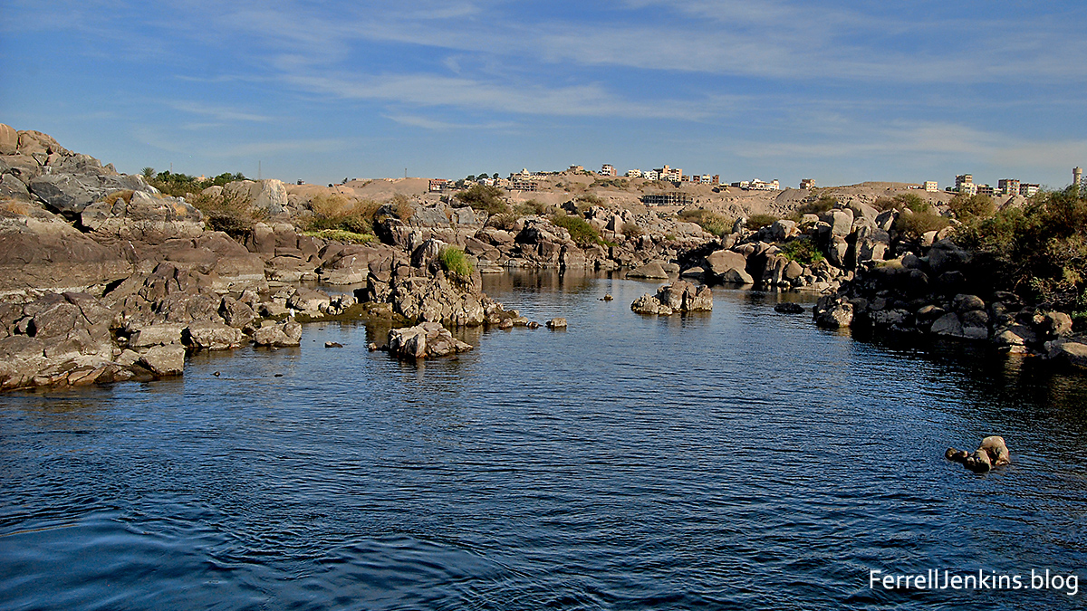
The First Cataract: The Gatekeeper
Located right at Aswan, this is the only one in modern Egypt. Most people see it today from the deck of a felucca. It’s beautiful, dotted with islands like Philae and Elephantine. Historically, this was the "Southern Gate." It was the primary trading post for gold, ivory, and incense coming out of sub-Saharan Africa.
Because the river was so difficult to navigate here, everything had to be unloaded. This created a massive economic hub. You’ve got the Old Aswan Dam and the High Dam here now, which have changed the water flow significantly, but the granite outcrops are still there, stubbornly sticking out of the water.
Moving South: The Lost Cataracts of Sudan
As you move south into Sudan, the map of Nile cataracts gets a bit more complicated—and a lot more somber.
The Second Cataract is gone. Well, it's not "gone" in a geological sense, but it’s underwater. When the Aswan High Dam was built in the 1960s, the resulting reservoir—Lake Nasser (or Lake Nubia on the Sudanese side)—completely submerged it. This was the location of the famous Great Cataract and the massive Middle Kingdom fortresses like Buhen. Archaeologists had to scramble to save what they could before the water rose. Today, it’s a silent world beneath hundreds of feet of water.
The Third Cataract and the Kerma Culture
Further south, near Hannek, you hit the Third Cataract. This area is stunning. It’s where the river takes a massive "S" curve. If you’re tracking this on a map, you’ll notice the Nile actually flows southwest for a while here.
This was the heart of the Kerma Kingdom. Unlike the Egyptians, the people of Kerma didn't see the cataract as a wall; they saw it as a shield. The rapids here are particularly rocky and shallow, making it nearly impossible for a large enemy fleet to pass through unannounced.
The Fourth and Fifth: The Dangerous Middle
The Fourth Cataract, located near Karima, used to be one of the most rugged. It’s now largely affected by the Merowe Dam. Before the dam, this was a 75-mile stretch of absolute chaos. The river narrows, the current picks up speed, and the rocks are everywhere.
The Fifth Cataract is located after the Nile meets the Atbara River. It’s a bit more isolated. Travel writers in the 19th century used to describe the Fifth as a place of "melancholy desolation." It’s a stark landscape. The rocks here aren't just in the water; they spill out into the desert, creating a jagged, black-and-tan world that feels completely disconnected from the lush greenery of the Delta.
The Sixth Cataract: The Final Hurdle
The Sixth Cataract is the closest to Khartoum. It’s often called the Sabaloka Gorge. Here, the Nile cuts through a massive volcanic plug. It’s narrow. It’s deep. It’s dramatic.
For the Meroitic Kingdom, this was a vital defensive point. If you control the Sabaloka, you control the entrance to the fertile plains of the south. Today, it’s a popular day-trip spot for people living in Khartoum—or at least it was before the recent instability. You can take a boat out, eat some fresh fish, and watch the water churn through the gorge. It’s the last major geographical obstacle before the White and Blue Niles meet.
Mapping the Impact on Modern Travel and Geopolitics
When you look at a map of Nile cataracts today, you’re looking at more than just geology. You’re looking at a map of energy.
- Dams: The cataracts are the perfect spots for hydroelectric dams because of the natural drop in elevation.
- Political Tension: The Grand Ethiopian Renaissance Dam (GERD) is the big talking point now, but the cataracts in Sudan and Egypt have been the site of dam projects for a century.
- Archaeological Loss: Every time a cataract is dammed, we lose history. The Fourth Cataract was home to thousands of unexcavated sites that are now underwater.
It’s a trade-off. Electricity for history. It’s a tough sell depending on who you ask.
The sheer scale of the Nile is hard to wrap your head around until you see these barriers. We often think of rivers as highways. For most of human history, the Nile was a highway with six massive toll booths that required immense physical labor to pass.
What Most Maps Get Wrong
Most digital maps don't show the seasonal variation. During the "Inundation" (the flood season), some of these cataracts almost disappeared. The water rose so high the rocks were buried. During the dry season? They were impassable. If you're looking at a static map, you're missing the heartbeat of the river.
Also, don't expect to see "waterfalls." If you go looking for a mini-Victoria Falls, you’ll be disappointed. You’re looking for "rapids on steroids."
Making Use of This Information
If you're a history buff, a traveler, or just someone obsessed with geography, understanding these six points is the key to understanding the Nile. You can't grasp why the Kingdom of Kush rose where it did without seeing the Third Cataract. You can't understand why Egypt’s influence waxed and waned without seeing the First.
Actionable Steps for the Curious:
- Use Google Earth Pro: Don't just look at a 2D map. Zoom into the Sabaloka Gorge (Sixth Cataract) and the area around Dal (near the Second/Third). The satellite imagery shows the "braided" nature of the river much better than a standard map.
- Check the UNESCO Nubia Campaign records: If you want to see what the Second Cataract looked like before it was flooded, look up the 1960s salvage mission archives. The photos of the Buhen fortress are mind-blowing.
- Track the "S" Curve: Open a map and look at the massive bend the Nile takes between the Third and Fourth cataracts. Note how the river flows backward (South) for a stretch. This is one of the most geologically interesting parts of the entire African continent.
- Compare Modern vs. Ancient Hydrography: Look at maps from the 1800s (like those from the Royal Geographical Society) and compare them to modern satellite views. You'll see exactly how much the landscape has been altered by human engineering.
The Nile isn't a static line on a page. It's a living, breathing obstacle course that dictated the fate of some of the greatest civilizations in human history.