Imagine a wall of water so tall it would dwarf the Empire State Building. Sounds like a bad disaster movie plot, right? But in 1958, it actually happened. We aren't talking about a "big wave" like you see at Mavericks or Nazaré. We are talking about the largest ever recorded tsunami, a literal skyscraper of water that tore through a remote Alaskan fjord and changed everything we thought we knew about geology.
It was July 9. Nighttime.
Howard Ulrich and his seven-year-old son were anchored in Lituya Bay, a T-shaped inlet in the Alaskan Panhandle. It’s a beautiful, eerie place. Glaciers sit at the back of the bay like sleeping giants. Suddenly, the world started shaking. A massive 7.8 magnitude earthquake hit the Fairweather Fault. But the earthquake wasn't the main event. The real nightmare was what the shaking loosened from the cliffs above.
The Moment the Mountain Fell
Basically, a massive chunk of rock—about 40 million cubic yards of it—decided it didn't want to be a mountain anymore. It fell 3,000 feet straight into Gilbert Inlet. If you're trying to visualize that, picture a block of rock roughly the size of a city center just plummeting into the sea.
The displacement was instant.
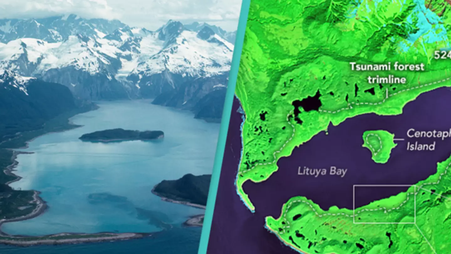
The water didn't just ripple; it surged upward with such violence that it reached an unthinkable height of 1,720 feet (524 meters). That’s the official number from the United States Geological Survey (USGS). It’s a height that scientists initially struggled to believe. Honestly, if you saw a wave that tall coming at you, your brain probably wouldn't even register it as water. You’d just see a moving wall of the world.
Why Lituya Bay was a "Perfect Storm"
You might wonder why we don't see 1,700-foot waves in the middle of the Pacific. Well, the largest ever recorded tsunami wasn't a "teletsunami" caused by the seafloor shifting over thousands of miles. It was a "megatsunami" caused by a massive localized displacement in a confined space.
Think of it like dropping a heavy brick into a bathtub. The water has nowhere to go but up and out.
Lituya Bay is narrow. It’s deep. When that rock hit, the energy was focused, not dissipated. The wave literally stripped the soil and every single tree off the surrounding hillsides. When researchers arrived later, they found a "trimline"—a clear, stark boundary where the green forest simply stopped and bare, grey rock began. That line was over 1,700 feet up. It’s still visible today if you know where to look, though the new growth is finally starting to blur the edges.
Survivors of the Unsurvivable
Most people assume everyone in the bay died. They didn't.
Howard Ulrich somehow managed to get his boat, the Edrie, over the crest of the wave. He described it as a wall of water that seemed to cover the sky. He literally told his son to put on a life jacket because they were about to die. Then, through some miracle of physics and luck, the boat was lifted up, carried over the trees, and then washed back into the center of the bay as the water receded.
Another boat, the Sunbury, wasn't so lucky. It was swallowed. A third boat, the Badger, was carried over the spit at the mouth of the bay—an area of land that should have been way out of reach—and the passengers actually saw the tops of the trees beneath them before the boat eventually sank. They survived in a skiff.
The Science of Megatsunamis
Before 1958, many geologists didn't really buy the idea of megatsunamis. They thought waves were limited by certain physical constraints of the open ocean. Lituya Bay forced a total rewrite of the textbooks.
Dr. Don Miller of the USGS was the guy who did the heavy lifting on the ground. He spent years mapping the trimlines and calculating the math. He proved that it wasn't just "splashing." It was a coherent mass of water. This discovery changed how we assess risk in places like the Canary Islands or the fjords of Norway.
We now know that these events are rare, but they are a distinct category of disaster. A "regular" tsunami might be 30 to 100 feet tall—which is already terrifying. But a megatsunami? It's a different beast entirely. It’s gravity and momentum working in a terrifyingly efficient way.
Can It Happen Again?
Probably. Maybe not tomorrow, but the geology of the Pacific Northwest and Alaska is restless.
The Fairweather Fault is still active. There are massive glaciers still hanging over deep water. The same thing could happen in places like Barry Arm, Alaska, where scientists are currently monitoring a "slow-motion" landslide that could trigger a similar event. The stakes are higher now because there are more cruise ships and fishing vessels in these waters than there were in the 50s.
If you're traveling to these areas, it’s not something to be paranoid about, but it's something to respect. Nature in the North doesn't play by the rules we're used to in the lower latitudes.
How to Stay Safe in Tsunami Country
If you ever find yourself in a coastal area and feel a long, rolling earthquake—the kind that lasts a minute or more—don't wait for a siren. Just go.
- Move to high ground immediately. You don't need to be at 1,700 feet, but 100 feet is usually the safety benchmark for standard tsunamis.
- Forget the "look and see" approach. If the water recedes and exposes the seabed, that's not a photo op. It's the ocean drawing back its fist to punch. Run.
- Stay there. Tsunamis are a series of waves. Often, the second or third wave is the one that actually catches people off guard because they thought the danger had passed.
- Boaters should go deep. If you're on a boat and have time, heading to water deeper than 100 fathoms (600 feet) is generally safer than trying to dock. In the 1958 case, the deep water in the center of the bay was actually the only reason the Edrie survived.
The largest ever recorded tsunami reminds us that the Earth is a lot more dynamic than we like to admit. It’s a reminder that sometimes, the landscape doesn't just change over millions of years—it changes in thirty seconds.
If you're interested in the raw power of the Pacific, your next step should be checking the real-time monitoring maps provided by the National Tsunami Warning Center. They track seismic activity across the Fairweather Fault and the Aleutian Trench 24/7. Understanding the "why" behind the wave makes the history a lot less like a ghost story and a lot more like a survival manual. Stay aware of the local "trimlines" when you're hiking Alaskan coastal trails; they are the silent scars of a planet that occasionally loses its temper.