If you look at a military bases in okinawa japan map, the first thing that hits you is how crowded it feels. It’s not just a few dots on a piece of paper. Honestly, it’s more like the island is being squeezed. Okinawa makes up less than 1% of Japan’s total land, yet it hosts roughly 75% of the U.S. military facilities in the country. It’s a lot.
People call it the "Keystone of the Pacific." Strategically, that makes sense. It’s sitting right there between Southeast Asia, China, and the rest of Japan. But for the people living in Ginowan or Chatan, it’s not a "keystone." It’s home. And that home has a massive fence running through it.
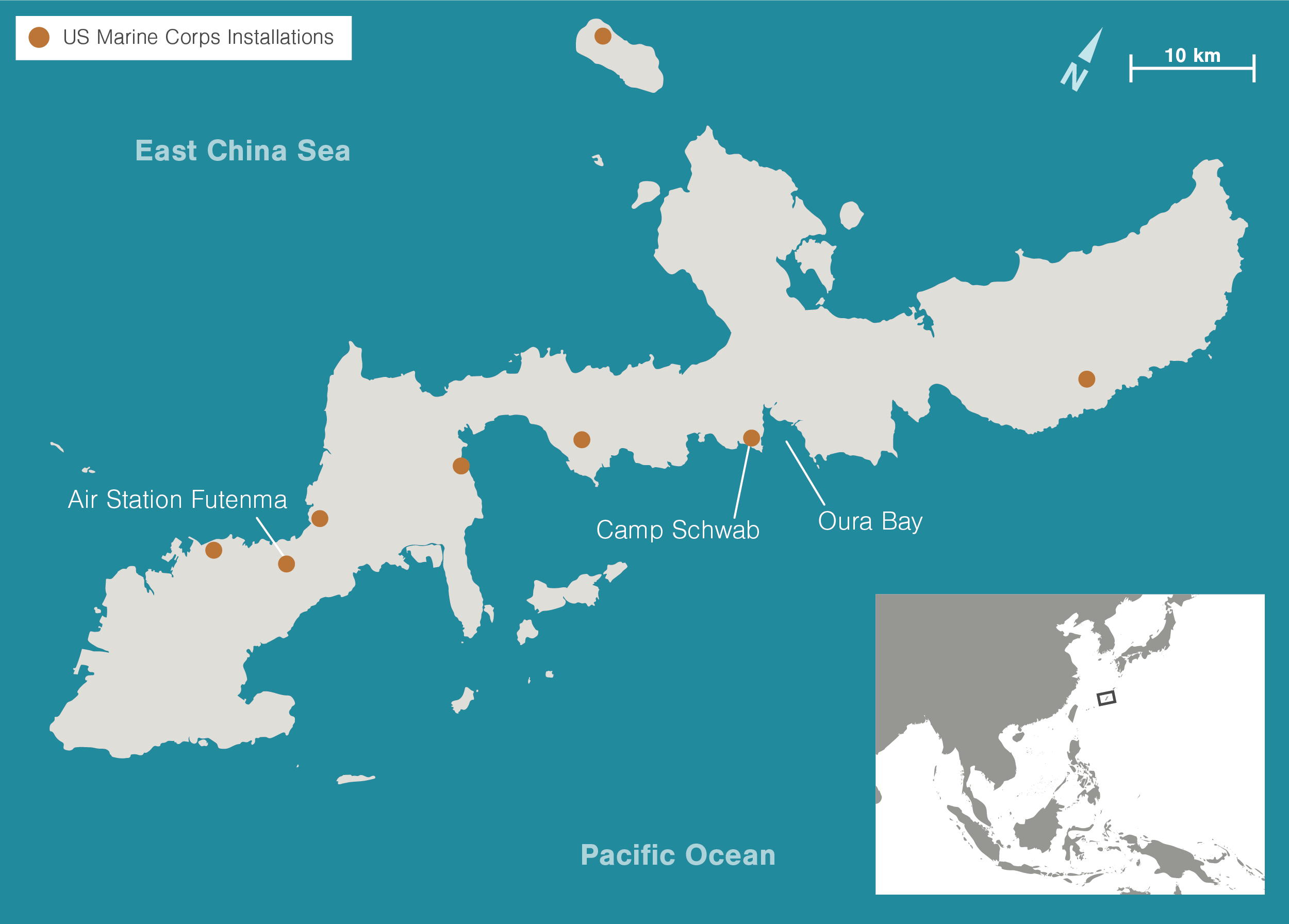
The Big Three: Kadena, Futenma, and Foster
When you zoom in on a map of central Okinawa, three names dominate the landscape. These aren't just little outposts. They are cities within cities.
Kadena Air Base is the monster. It is the largest U.S. air installation in East Asia. If you’ve ever driven past it on Highway 58, you know how it goes. The fence just keeps going and going. It’s basically 6,000 acres of runways, hangars, and suburban-style housing. Two massive runways dominate the center. The noise? It’s something else. Imagine trying to teach a classroom of kids while an F-15 is taking off a few hundred yards away. That’s life in Kadena Town.
Then you have MCAS Futenma. This one is famous for all the wrong reasons. It’s often called "the most dangerous base in the world." Why? Look at a map. The city of Ginowan has completely surrounded it. The runway sits right in the middle of high-density housing, schools, and hospitals. When a Marine Corps helicopter has a "mishap"—and it’s happened—there isn't exactly an empty field for it to land in.
Camp Foster (or Camp Zukeran) acts as the administrative heart. It’s where the high-level commands live. If you’re looking for the big hospital or the main shopping centers (the BX/PX), this is where you end up. It bridges several different municipalities, effectively cutting off local traffic and forcing everyone onto the main coastal roads.
North vs. South: The Great Divide
The military footprint shifts as you go north. While the central area is urban and tight, the north is rugged.
- Camp Hansen & Camp Schwab: These are where the "heavy" training happens. Live-fire ranges, jungle warfare maneuvers—it's loud and messy.
- The Northern Training Area: This is a massive chunk of the Yanbaru forest. It’s beautiful, full of endangered species, and also where Marines learn to survive in the brush.
- White Beach Naval Facility: This is on the Katsuren Peninsula. It’s the primary pier for the U.S. Navy. If a carrier or a sub is visiting, this is where they dock.
The northern bases are often the focus of the biggest political fights. Specifically, Henoko. The plan has been to move the Futenma operations up to a new runway built over the water at Camp Schwab. It’s been "in the works" for decades. Protesters have been sitting at the gates for years. Environmentalists are worried about the dugongs (sea cows) and the coral. As of early 2026, the construction is still a massive point of friction between the Okinawan government and Tokyo.
What the Map Doesn't Always Show
A map tells you where the fences are, but it doesn't tell you what happens across them.
There’s a weird, symbiotic relationship here. You’ve got the "Base Towns." Places like Gate 2 Street in Okinawa City. It feels like a slice of 1980s America dropped into Japan. Taco rice—Okinawa's unofficial national dish—was literally invented to feed hungry GIs who wanted something that tasted like home but used local ingredients.
But there is deep-seated fatigue.
Okinawans remember the Battle of Okinawa. They remember the decades of U.S. administration that didn't end until 1972. When you see a map of military bases in Okinawa Japan today, you’re looking at land that was often "surveyed" with bayonets and bulldozers in the 1950s. That history doesn't just go away because there’s a Starbucks on base now.
Dealing with the Noise and the "PFAS" Problem
Lately, the conversation has shifted from "where are the bases" to "what is coming out of them." Environmental concerns are the new frontline.
There’s been a lot of heat regarding PFAS (per- and polyfluoroalkyl substances). These are "forever chemicals" used in firefighting foam. Investigations have found high levels in the water around Kadena and Futenma. For a small island that relies on its groundwater, this is terrifying. The Okinawan government has been pushing for access to the bases to do their own testing, but the Status of Forces Agreement (SOFA) makes that... complicated.
Then there’s the crime. It’s a sensitive topic. While the vast majority of service members are just doing their jobs, high-profile incidents—like the sexual assault cases that made headlines in late 2024 and throughout 2025—fuel the fire. It leads to curfews. It leads to "off-limits" areas. It keeps the tension high.
Navigating the Island Today
If you're visiting or moving there, understanding the military bases in okinawa japan map is actually practical for daily life.
- Traffic is a monster. Because the bases take up the flat, central land, the main roads (Route 58 and Route 330) are permanent bottlenecks.
- Housing is a split market. You have "American-style" housing built specifically for off-base military families. They have big ovens and dryers. Local Okinawan apartments are much smaller and usually don't have those amenities.
- The "Fence" is real. You can be in a ultra-modern Japanese neighborhood one second, and the next, you're looking at a rusted chain-link fence with "U.S. Property" signs. It’s a constant juxtaposition.
What’s Next for the Map?
Is the footprint shrinking? Kinda. But slowly.
Some land has been returned. The "West Futenma" area and parts of Camp Kinser are slowly being handed back to local control. You see new shopping malls and hospitals popping up where barracks used to be. But the big stuff—the airfields and the training grounds—isn't going anywhere fast.
The tension between China and Taiwan keeps Okinawa "valuable" in the eyes of military planners. As long as that's the case, the map is going to stay crowded.
If you want to understand Okinawa, don't just look at the tourist maps of Shuri Castle or the Churaumi Aquarium. Look at the gray blocks on the satellite view. Look at how the cities have to bend and curve around the runways. That’s where the real story of the island is written.
Practical Steps for Understanding the Landscape:
- Check out the Okinawa Prefectural Government’s military base affairs website for the most accurate, non-military maps.
- If you're driving, use apps like Waze; they often have better "base gate" data than standard Google Maps.
- Visit the Sakima Art Museum. It’s located right next to Futenma and offers a literal rooftop view of the base alongside art that deals with the island's trauma.
The map of Okinawa is a living document of a very long, very complicated relationship. It's not just geography; it's a daily reality for over a million people.