It was the day after Christmas. Boxing Day, 2004. People were shaking off the holiday fog on beaches in Thailand, Sri Lanka, and Indonesia. Then, the ground moved. But it didn't just move; it snapped. Deep under the Indian Ocean, two tectonic plates that had been grinding against each other for centuries finally gave way. The result was a $9.1$ magnitude earthquake, the third-largest ever recorded by a seismograph. It lasted nearly ten minutes. Most quakes are over in thirty seconds. This one just kept going.
The water didn't come as a giant, cresting Hollywood wave. Not at first. It looked more like a rising tide that wouldn't stop, a "bore" of water that eventually turned into a churning wall of debris. It traveled across the ocean at the speed of a jet airliner. Because there was no warning system in the Indian Ocean at the time, people didn't know why the tide had suddenly receded, exposing fish and coral. Some actually walked out onto the sand to see. They had no idea the ocean was just catching its breath before the strike.
The Science of the 2004 Indian Ocean Earthquake and Tsunami
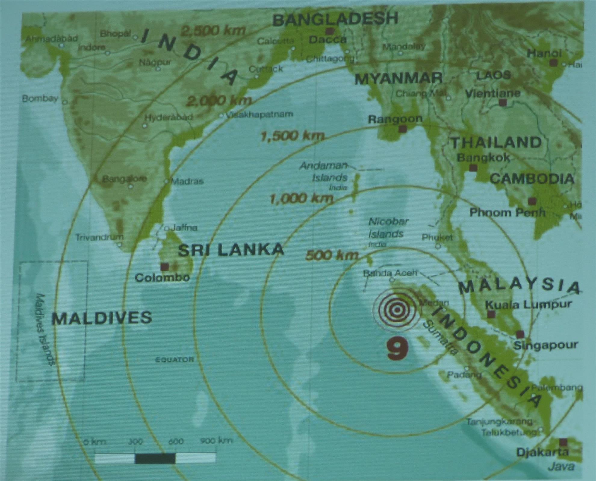
The sheer physics of this event are hard to wrap your head around. Basically, the India Plate was pushed under the Burma Plate. This is what scientists call a megathrust earthquake. When that plate snapped upward, it displaced a massive volume of water. We’re talking about a vertical shift of the seafloor by several meters along a 1,500-kilometer fault line.
Think about the energy involved. Some estimates suggest the energy released was equivalent to 23,000 Hiroshima-type atomic bombs. It was so powerful that the entire planet vibrated by as much as 1 centimeter. It even slightly altered the Earth’s rotation, shortening the day by a fraction of a microsecond.
Why the waves were so deadly
In the deep ocean, tsunami waves are barely noticeable. They might be only a few inches high. But as they hit the shallow coastal shelf, they slow down and pile up. This is "shoaling." In Aceh, Indonesia, the waves reached heights of 30 meters. That’s a ten-story building made of salt water and everything the water picked up on its way—cars, trees, houses, and concrete.
The geography of the Indian Ocean made things worse. There were no deep-sea sensors (DART buoys) in the region. The Pacific had them because of the 1964 Alaska quake, but the Indian Ocean was considered "quiet." That assumption cost 230,000 lives. It’s a staggering number. In some places like the Andaman and Nicobar Islands, the waves arrived so fast there was zero chance of escape. In others, like Somalia, the waves arrived hours later, yet people were still caught off guard because the news didn't travel fast enough.
The Day the World Changed for Geologists
For years, the scientific community had focused on the Ring of Fire in the Pacific. The 2004 Indian Ocean earthquake and tsunami forced a total rewrite of the risk maps. Dr. Kerry Sieh and his team at the Earth Observatory of Singapore had actually been studying coral growth patterns in Sumatra for years, noticing that major uplifts happened every couple of centuries. They knew a big one was coming, but nobody knew it was coming that day.
The tragedy highlighted a massive gap between high-level science and local government action. Even if the seismic stations in Hawaii and Australia saw the quake, they didn't have the contact info for the local police in small Thai fishing villages. The "last mile" of communication was broken.
- Aceh, Indonesia: Hit first, hit hardest. Over 160,000 dead.
- Sri Lanka: The "Queen of the Sea" train was derailed by the wave, killing over 1,700 people in one of the worst rail disasters in history.
- Thailand: Tourists and locals alike were swept away.
- India: The southeastern coast was devastated, specifically Tamil Nadu.
Misconceptions About What Happened
Most people think everyone died from drowning. Honestly, a lot of the trauma came from the debris. When you’re in a tsunami, you’re not swimming in water; you’re being tossed in a blender of wood, glass, and metal.
Another big myth? That animals have a "sixth sense." While there were reports of elephants in Thailand running for higher ground or flamingos in India leaving low-lying nesting areas, it wasn't magic. Animals are just hyper-sensitive to low-frequency vibrations (infrasound) that humans can't hear. They felt the ground shaking or heard the "roar" of the approaching wave long before we saw it. We could have survived if we’d just paid attention to the same physical cues.
The Long-Term Impact on Global Policy
After 2004, the UN stepped in. The Intergovernmental Oceanographic Commission (IOC) helped set up the Indian Ocean Tsunami Warning and Mitigation System. Now, there are sensors. There are sirens. There are blue "Tsunami Evacuation Route" signs in places that never had them before.
But it’s not just about the tech. It’s about education. In 2004, a 10-year-old British girl named Tilly Smith saved dozens of people on a beach in Phuket because she had just learned about tsunamis in school. She recognized the "frothy" water and the receding tide. She told her parents, they told the hotel, and the beach was cleared. One kid with one piece of information did what a multi-billion dollar satellite network couldn't do at the time.
The trauma that stays behind
We often talk about the death toll, but the survivors' stories are equally heavy. Entire coastal economies vanished. In the Maldives, the tsunami actually flooded some islands completely, tainting the freshwater lens with salt water. This created a long-term drinking water crisis that lasted years. The environmental damage was also huge. Mangrove forests were ripped out, and coral reefs were smothered by silt.
Interestingly, some areas with healthy mangroves fared better. The trees acted as a natural shock absorber. This has led to a big push in "green infrastructure" lately—planting trees instead of just building concrete sea walls. It’s cheaper and often more effective.
What We’ve Learned Since Then
Since the 2004 Indian Ocean earthquake and tsunami, we've had other major events, like Tohoku in 2011. Each one teaches us that even with the best tech, nature is unpredictable. The 2004 quake was a "silent" killer for many because the earthquake wasn't felt strongly in places like Sri Lanka, even though the wave it produced was deadly.
We now know that the "receding water" trick doesn't always happen. Depending on whether the "trough" or the "crest" of the wave hits first, the water might just come rushing in without any warning at all. You can't rely on the ocean to give you a sign.
Taking Action: How to Prepare for the Unthinkable
If you live near a coast or travel to volcanic/seismic zones, you need more than just a "hope for the best" plan. The 2004 disaster showed that minutes—even seconds—are the difference between life and death.
1. Know the natural warning signs. If the ground shakes violently for a long time, don't wait for a siren. Get to high ground. If the ocean acts weird—pulling back or making a loud "freight train" noise—run inland immediately. Do not go to the beach to take a video.
2. Map your "High Ground." Most people don't realize that you only need to get about 30 meters (100 feet) above sea level or go 3 kilometers (2 miles) inland. Identify these spots before you check into a hotel.
3. Digital alerts are great, but have a backup. Phones fail. Towers go down. In a major quake, the power is going out. A battery-powered or hand-crank weather radio is old-school but reliable.
4. Support coastal restoration. Mangroves and sand dunes are the first line of defense. Protecting these ecosystems isn't just about "saving the planet"—it's about creating a physical buffer for your community.
The 2004 Indian Ocean earthquake and tsunami remains a benchmark for disaster response. It changed how the world looks at the sea. It reminded us that we live on a restless, moving crust. We can't stop the plates from shifting, but we can definitely stop being surprised by what happens when they do.
Keep an eye on the tide. Pay attention to the ground. And if you're ever in doubt, just head for the hills.