Ever tried to find the Columbia River on US map and felt like you were looking at a giant, liquid zigzag? It's not just you. This thing doesn't follow the rules. While most rivers try to take the easiest path to the sea, the Columbia decided to punch through a literal mountain range.
Most people think of it as just "that line between Oregon and Washington." Honestly, it’s so much more. It's the lifeblood of the Pacific Northwest, a massive energy factory, and a 1,243-mile-long history book. If you're looking at a map of the United States, you'll find it tucked into the upper-left corner, carving a path from the Canadian Rockies all the way to the Pacific Ocean.
Where Exactly Is the Columbia River on a Map?
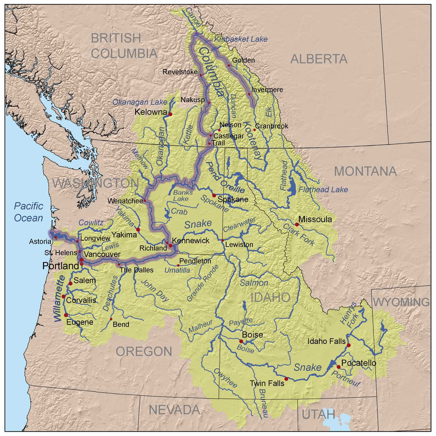
Let's get oriented. If you pull up a map, start your eyes in British Columbia, Canada. The river actually starts there, flowing north first—which is weird—before looping south into Washington State.
Basically, the river enters the U.S. in the northeast corner of Washington. From there, it makes a giant, sweeping "S" curve known as the Big Bend. It flows south, then west, then south again, eventually hitting the border between Washington and Oregon. This is where most people recognize it. For the final 300-ish miles of its journey, it acts as the official state line, heading straight west until it dumps into the Pacific at Astoria.
It drains an area roughly the size of France. Seriously. The Columbia River Basin covers 258,000 square miles and touches seven different states:
- Washington (obviously)
- Oregon (the other half of the main stem)
- Idaho (home to the massive Snake River tributary)
- Montana
- Wyoming
- Nevada
- Utah
Even though the river itself doesn't flow through Vegas, the water that lands in the mountains of Nevada eventually finds its way to the Columbia.
The Gorge: A Hole in the Mountains
Look at the Cascade Mountains on your map. It’s that long spine of volcanoes running from Canada down to California. Notice how there’s only one spot where a river cuts completely through them at sea level? That's the Columbia River Gorge.
It’s spectacular. 15,000 years ago, massive Ice Age floods—we’re talking walls of water hundreds of feet high—blasted through here. They tore the landscape apart. These "Missoula Floods" are why the Gorge has those vertical basalt cliffs and the highest concentration of waterfalls in North America. Multnomah Falls? Yeah, you can thank a prehistoric flood for that.
Why This Gap Matters
Because it's the only sea-level break in the mountains, it’s the ultimate wind tunnel. That’s why Hood River is the windsurfing capital of the world. It’s also why the Oregon Trail ended up here. Pioneers had to decide: do we try to haul our wagons over the brutal slopes of Mount Hood, or do we risk it on rafts down the rapids of the Columbia? Most of them chose the river, and quite a few didn't make it.
The Powerhouse of the Nation
If you look at the Columbia River on US map today, you’ll see a series of "lakes" instead of a free-flowing river. These are actually reservoirs behind 14 major dams on the main stem.
The Columbia is a beast when it comes to electricity. The Grand Coulee Dam in central Washington is the biggest power producer in the United States. It's so big you could fit every pyramid in Egypt inside it. These dams provide about 40% of the entire country’s hydropower.
But there’s a trade-off.
The dams changed everything for the salmon. Historically, 10 to 16 million salmon returned to the Columbia every year. Today? It’s more like 2 million, and most of those are from hatcheries. It's a huge point of contention in 2026. Tribes, environmentalists, and the government are constantly debating whether to remove some of these dams—specifically on the Snake River—to save the fish from extinction. It’s a messy, complicated fight between "green" carbon-free energy and ecological survival.
Navigation and the "Graveyard of the Pacific"
Follow the river all the way to the left on your map. Where the blue of the river meets the blue of the ocean, there’s a spot called the Columbia River Bar.
Ship captains hate it.
The force of the river hitting the Pacific tide creates some of the most dangerous water on Earth. Over 2,000 ships have wrecked there since the 1700s. Even today, specialized "Bar Pilots" have to board every large ship to steer it through that narrow, shifting channel.
Once they get past the bar, the river becomes a massive highway. Huge barges carry about 60% of all U.S. wheat exports down the Columbia-Snake system. If you're eating bread in Asia, there’s a good chance the wheat traveled down this river on a map first.
Modern Day: Threats and Travel in 2026
If you’re planning to see the river in person this year, keep a few things in mind. The Gorge is more popular than ever.
- Permits are a thing now: To see Multnomah Falls or drive the historic highway during peak summer months, you often need a timed-use permit. Don't just show up; check the "Ready, Set, Gorge" site first.
- Temperature is the new enemy: In 2026, we’re seeing record-high water temperatures. When the water hits 68°F (20°C), salmon basically stop moving. They just sit there and get stressed. Groups like Columbia Riverkeeper are pushing for "cold water refuges" to keep the runs alive.
- The Hanford Factor: On the "Big Bend" in Washington, you’ll pass the Hanford Site. It was part of the Manhattan Project and is currently the most contaminated nuclear site in the Western Hemisphere. They're still cleaning it up. It’s a weird, eerie contrast to the natural beauty of the rest of the river.
How to Explore the Columbia Yourself
Don't just look at the Columbia River on US map—go see it.
Start in Astoria. It’s moody, foggy, and feels like a 19th-century fishing village. Visit the Columbia River Maritime Museum to see why the "Bar" is so terrifying.
Then, drive east through the Gorge. Stop in Cascade Locks for ice cream and watch the massive locks move ships upriver. Hike the Dog Mountain trail in May if you want to see more wildflowers than you thought existed in one place.
Finally, head out to the Tri-Cities in Washington. This is where the Snake River joins the Columbia. It's high desert country—dry, brown, and beautiful in a stark way. You'll see the massive irrigation pipes that turn this desert into the "Appalachia of Apples."
Actionable Next Steps for Your Trip:
- Check the flow: Use the USGS water dashboard to see real-time river levels.
- Download Offline Maps: Cell service is notoriously spotty once you get deep into the Gorge or the remote sections of the Big Bend.
- Book the "Bar" Tour: If you have a stomach for waves, take a charter boat out of Astoria to see the Coast Guard training in the heavy surf. It's a humbling reminder of why this river has shaped the West for centuries.
The Columbia isn't just a line on a map. It's a working river, a sacred site, and a massive battery all rolled into one. Whether you're interested in the history of the Oregon Trail or just want to see a 600-foot waterfall, this river delivers. Just remember to respect the current—it’s a lot stronger than it looks on paper.