If you’ve spent any time looking at a map of Israel, Gaza, the West Bank, and Palestine, you probably noticed it looks like a jigsaw puzzle that someone dropped and tried to piece back together in the dark. It is complicated. Honestly, it’s more than just lines on paper; it's a living, breathing history of displacement, security, and identity that changes depending on who you ask or what year you're looking at.
The geography is tiny. You can drive from the Mediterranean Sea to the Jordan River in less than two hours. Yet, within that small space, the borders—some recognized, some disputed, some walled off—dictate every aspect of life for millions of people.
To really get what’s happening, you have to look past the static shapes. You have to see the checkpoints, the "Area A, B, and C" designations that make the West Bank look like Swiss cheese, and the physical isolation of the Gaza Strip.
What the Map of Israel, Gaza, the West Bank, and Palestine Actually Shows
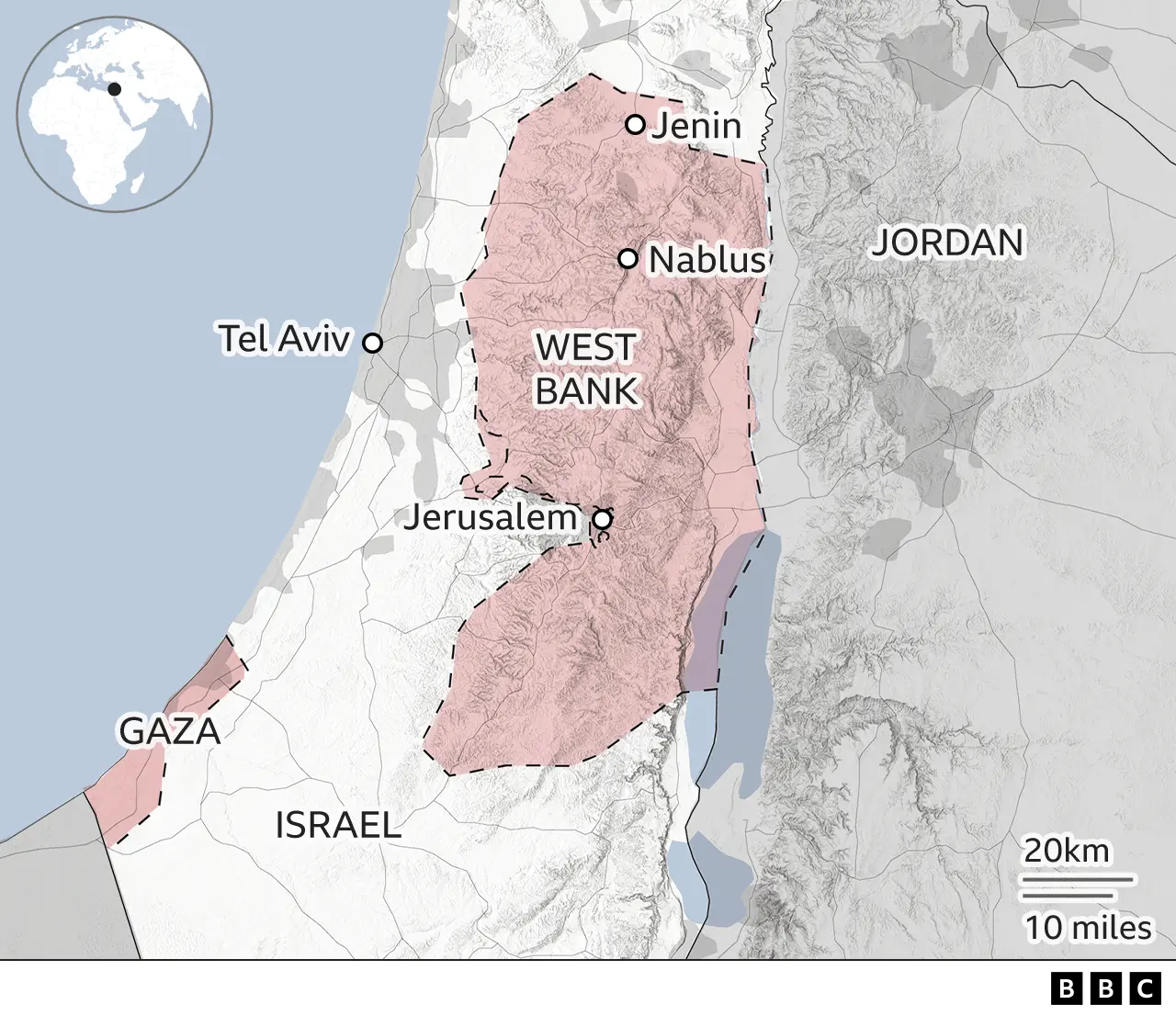
When you look at a modern map, you see Israel proper, the West Bank, and the Gaza Strip. But these aren't just three distinct blobs.
The Green Line is the most important boundary you’ve probably never seen in person. It’s the 1949 Armistice line that followed the first Arab-Israeli war. For many in the international community, this remains the "official" border for a future two-state solution. However, if you go there today, that line is basically invisible on the ground. It’s been blurred by decades of settlement expansion and security infrastructure.
Israel sits in the middle and to the west. The West Bank is to the east, hugging the Jordan River. Gaza is that tiny, densely populated rectangle on the southwest coast bordering Egypt.
The term "Palestine" is used by the United Nations and over 130 countries to refer to the West Bank and Gaza collectively. However, the Palestinian Authority (PA) only has varying degrees of control over parts of these areas. In Gaza, the PA hasn't had real power since 2007, when Hamas took over. So, the map isn't just about land; it’s about fragmented governance.
The West Bank: A Map Within a Map
If you zoom into the West Bank, things get weird. Following the 1993 Oslo Accords, the land was split into three zones: Area A, Area B, and Area C.
Area A is under Palestinian civil and security control. It includes major cities like Ramallah, Nablus, and Bethlehem. If you’re a tourist, these are the places you visit to see the Church of the Nativity. Area B is Palestinian civil control but Israeli security control. Then there’s Area C.
Area C makes up about 60% of the West Bank. It is under full Israeli control. This is where most Israeli settlements are located. Because Area C surrounds Areas A and B, a Palestinian traveler often has to pass through Israeli-controlled territory just to get from one Palestinian city to another. It makes the "map" feel less like a country and more like a collection of islands.
Why the Gaza Strip is Geographically Unique
Gaza is different. It’s roughly 25 miles long and only 3 to 7 miles wide. It’s one of the most crowded places on Earth. Unlike the West Bank, there are no Israeli settlements inside Gaza; Israel withdrew its troops and settlers in 2005.
However, the map of Gaza is defined by its perimeter. Since 2007, Israel and Egypt have maintained a blockade. This means the borders are heavily fortified with fences, sensors, and "buffer zones" where Palestinians are often restricted from farming or even approaching. When you see a map of Gaza, you’re looking at an area that is physically disconnected from the West Bank, even though they are meant to be part of the same future state. The 30-mile gap between them is Israeli territory.
The Role of East Jerusalem
You can't talk about the map of Israel, Gaza, the West Bank, and Palestine without talking about Jerusalem. It’s the heart of the whole thing.
Israel claims all of Jerusalem as its undivided capital. Palestinians claim East Jerusalem as the capital of their future state. On most international maps, the Green Line cuts right through the city. But since 1967, Israel has annexed East Jerusalem—a move not recognized by most of the world—and built a massive security barrier (often called the "Separation Wall") that snakes around the city's eastern outskirts.
This wall doesn't follow the Green Line. It cuts deep into West Bank territory in some places to include certain settlements on the "Israeli side" of the fence. This changed the map of the city forever. It turned neighborhoods that were once five minutes apart into a two-hour journey through checkpoints.
Key Geographic Facts You Should Know:
- The Dead Sea: Shared by Israel, the West Bank, and Jordan. It’s the lowest point on Earth.
- The Jordan River: It forms the eastern border of the West Bank. Access to this water is a massive point of contention.
- The Philadelphi Corridor: A narrow strip of land along the border between Gaza and Egypt, which became a major focal point of military operations in 2024.
Misconceptions About the "1967 Borders"
People throw the term "1967 borders" around a lot. It’s a bit of a misnomer. There were no "borders" in 1967; there were armistice lines.
Before the Six-Day War in 1967, Jordan occupied the West Bank, and Egypt occupied Gaza. After the war, Israel took control of both. When people say they want a return to the 67 lines, they’re usually talking about a map where the West Bank and Gaza are free of Israeli military presence and settlements.
But the reality on the ground has changed so much that "swapping" land is usually the only way negotiators think a map could work now. Imagine trading a piece of Israeli desert for a piece of the West Bank where a large settlement block sits. That’s the kind of complex math people are doing to try and make the map make sense.
How to Read Different Maps
Depending on who printed the map, you’ll see different things.
A map from the Israeli government might not show the Green Line at all, treating the entire area as one unit with different security zones. A map from a Palestinian NGO might emphasize the "fragmentation"—showing the hundreds of checkpoints, roadblocks, and "settler-only" roads that carve up the West Bank.
Google Maps actually handles this in a fascinating way. If you look at it from Israel, you might see different labels than if you look at it from another country. The dotted lines you see around the West Bank and Gaza signify that the borders are "disputed" or not internationally settled.
Actionable Insights for Researching the Region
If you are trying to understand the situation through geography, don't just look at one map. You need layers.
First, look at a topographical map. You'll see that the West Bank consists of high ground overlooking Israel's coastal plain, which is why Israel views it as a "strategic depth" security issue. Second, look at a water rights map. The mountain aquifer under the West Bank is a primary source of fresh water for the entire region.
Finally, use satellite imagery. If you zoom in on the West Bank via tools like Google Earth, you can see the difference between the red-roofed Israeli settlements and the flat-roofed Palestinian villages. This visual contrast tells you more about the current "map" than any political diagram ever could.
To stay truly informed, follow organizations like B'Tselem or Peace Now for maps of settlement growth, and the UN Office for the Coordination of Humanitarian Affairs (OCHA) for maps of movement and access restrictions. These sources provide the data that fills in the blanks between the lines. Understanding the map is about understanding that for the people living there, those lines aren't just ink—they are the boundaries of their freedom.