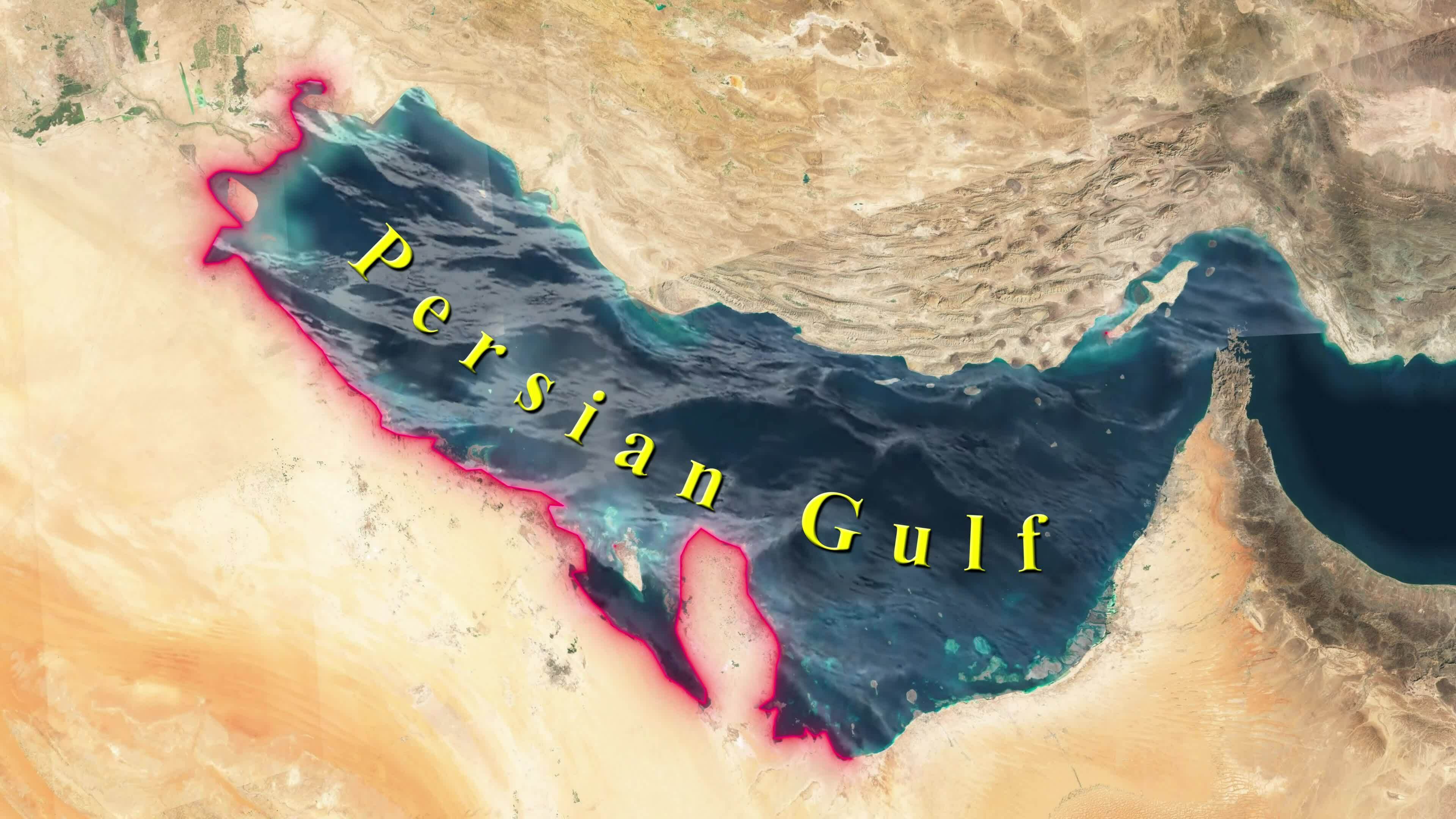
If you look at a Persian Gulf sea map today, you aren't just looking at a body of water. You are looking at one of the most crowded, politically charged, and economically vital strips of blue on the planet. It’s a shallow arm of the Arabian Sea, tucked between the Arabian Peninsula and southwestern Iran. Most people think it’s just a giant bathtub of oil. Honestly? It’s way more complicated than that.
It's about 600 miles long. At its widest, it’s about 210 miles across. But the part that keeps world leaders awake at night—the Strait of Hormuz—is only about 21 miles wide at its narrowest point. That’s basically the distance of a marathon. Imagine twenty percent of the world’s liquid petroleum passing through a gap that small every single day.
The Geography Most People Ignore
When you pull up a Persian Gulf sea map, the first thing that hits you is the bathymetry. Or, well, it should. Unlike the Mediterranean or the Red Sea, the Persian Gulf is remarkably shallow. We’re talking an average depth of only about 160 feet.
That’s nothing.
Because it’s so shallow, the water gets incredibly hot. In the summer, surface temperatures can hit nearly 95°F. It’s like swimming in a lukewarm soup. This shallowness also means the ecosystem is fragile. If there’s an oil spill, it doesn’t just "sink" into the abyss. It lingers. It hits the coral. It destroys the desalination plants that provide almost all the drinking water for cities like Dubai, Doha, and Kuwait City.
The sea floor isn't just flat sand either. It’s a jagged landscape of salt domes and tectonic ridges. These "hills" underwater are often where the massive oil and gas reservoirs are trapped. The Northern Dome/South Pars field, which sits right on the maritime border between Qatar and Iran, is actually the largest natural gas field in the world. On a map, it looks like a simple line dividing the sea. In reality, it’s a shared subterranean giant that dictates the foreign policy of half a dozen nations.
The Naming Dispute (It’s a Big Deal)
If you use a map that calls it the "Arabian Gulf," you might get banned from certain Iranian libraries. If you call it the "Persian Gulf" in some ultra-nationalist Arab circles, you’ll get a very cold shoulder. Historically, the term "Persian Gulf" has been the standard since the time of Ptolemy. Most international bodies, including the United Nations and the International Hydrographic Organization, still use it.
But names matter here. They represent claims to sovereignty and cultural identity.
Navigation Hazards and the Strait of Hormuz
Navigating this area is a nightmare. It isn't like the open Atlantic where you have miles of room to correct a mistake. On a Persian Gulf sea map used by a tanker captain, you’ll see strictly defined Traffic Separation Schemes (TSS). These are like highways in the ocean. You stay in your lane, or you risk a collision that could crash the global economy.
The Strait of Hormuz is the choke point.
The water there is deep enough for massive VLCCs (Very Large Crude Carriers), but there are islands like Abu Musa and the Greater and Lesser Tunbs that make things tricky. These islands are disputed. Iran controls them, but the UAE claims them. When you see a naval ship on the news "patrolling the Gulf," they are usually hovering right around these specific coordinates on the map.
Why the Coastlines are Changing
If you compare a Persian Gulf sea map from 1990 to one from 2026, the coastlines of the UAE and Qatar look totally different. Humans are literally rewriting the map.
Take the Palm Jumeirah or the World Islands in Dubai. These aren't just fancy real estate projects; they are massive engineering feats that have altered the local currents and sedimentation. While they look cool from space, they’ve also caused "siltation" issues. When you build out into the sea, the water flow changes. Some areas that used to be deep are now getting shallower because sand is piling up where it shouldn't.
The Life Below the Surface
It's easy to focus on the tankers and the warships. But the Persian Gulf is home to some of the hardiest marine life on Earth.
- Dugongs: These "sea cows" are everywhere near the coast of Abu Dhabi and Qatar. They graze on seagrass beds that are visible on high-resolution satellite maps as dark, mottled patches.
- Whale Sharks: Every year, these giants congregate near the Al Shaheen oil field off the coast of Qatar. Why? Because the platforms act as artificial reefs, attracting massive amounts of plankton and fish.
- Coral Reefs: These are some of the most heat-tolerant corals in the world. Scientists are studying them to see if they hold the secret to helping other reefs survive global warming.
The salinity in the Gulf is also sky-high. Evaporation is rapid, and there isn't much fresh water coming in. The Shatt al-Arab river (where the Tigris and Euphrates meet) is the main source of fresh water, but even that has been dwindling due to upstream dams in Turkey and Iraq. This makes the water extra salty and extra buoyant, which actually affects how ships sit in the water.
Hidden Wrecks and History
The Persian Gulf sea map is littered with ghosts. Because the Gulf has been a trade route for thousands of years, the floor is a graveyard of dhows, steamers, and modern casualties of the "Tanker War" in the 1980s.
During the Iran-Iraq war, hundreds of ships were attacked. Some sank. Others were scrapped. But if you look at a nautical chart today, you’ll see "Wk" symbols everywhere. These are wrecks. They are hazards for bottom-trawling fishing boats and interesting spots for the small but growing scuba diving community in the region.
Some of these wrecks are actually ecologically beneficial now, serving as hubs for snapper and grouper (locally known as Hamour).
Practical Insights for Using a Persian Gulf Map
If you’re actually planning to navigate these waters or just want to understand the region better, stop looking at Google Maps. It’s too simplified. You need to look at Admiralty Charts or digital equivalents like Navionics.
- Check the EEZ: The Exclusive Economic Zones are invisible lines in the water. Crossing into another country's EEZ without permission can lead to a very tense encounter with a coast guard. This is especially true near the "Grey Zone" borders in the northern Gulf.
- Watch the Tides: In the narrow channels near Kuwait and the Shatt al-Arab, tides can be incredibly strong. They can shift a small boat miles off course in an hour.
- Oil Infrastructure: The map is covered in "Restricted Areas." These surround oil rigs and loading terminals. Don't even think about getting close to these; they are protected by armed security and 24/7 radar.
- Desalination Intakes: Avoid areas marked as water intakes. These are vital for the survival of the desert cities nearby, and the suction can be dangerous for divers or small craft.
The Persian Gulf is a paradox. It’s an industrial zone that’s also a biological treasure. It’s a place of ancient tradition that is being physically reshaped by ultra-modern technology. Whether you’re interested in the geopolitics of the Strait of Hormuz or the migratory patterns of the hawksbill turtle, the map tells the story.
To get the most out of your research, always cross-reference satellite imagery with hydrographic charts. Satellite views show you the man-made islands and the green of the seagrass, but the charts tell you where the "deep water" really is—and where the danger lies. Always pay attention to the scale; the Gulf is smaller than it looks on a world map, which is exactly why it’s so crowded and why every square inch of that sea map is fought over so fiercely.